Myaterious Rig Jenn
Desert is the most mysterious phenomenon of Iran that‘s of fame worldwide. Mingled to people culture, history, art desert is an Iranian identity.
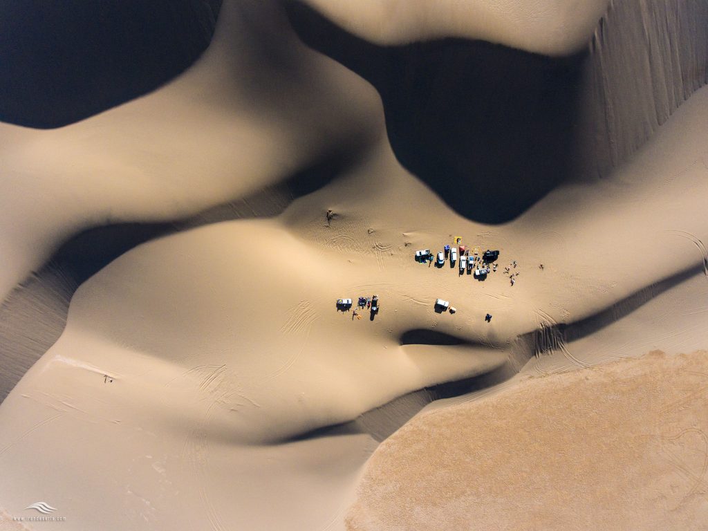
Sightseeing in a vast, unbounded land, filled with and sand dunes, burning salt flat hold all viewers’ attention. Travel accounts on the tourists visiting eye-catching sceneries of Iran has made a reference to the travelers experience with the deserts. Spending a night in desert, the viewers can feast their eyes to its starry night, blessed with a cool breeze they enjoy wonderful, spectacular picturesque painting of nature.
Jin means hidden and covered, because of that after Islam advent the angles were called Jin as they were hidden from human eyes.
Lack of water reservoir in this vast desert as well as natural obstacles like salty swamps, high sandy hills has caused the area to be out of human reach through the centuries. Spreading rumors and fairy tales about Jin may have been rooted in Koran-Moslems holy book- sayings that associated Jin with fire and heat, also due to great changes in temperature- dropping to below zero at night and boiling hot days –causes the stones break into dozen pieces and this has been signified as “Stone Moaning”.
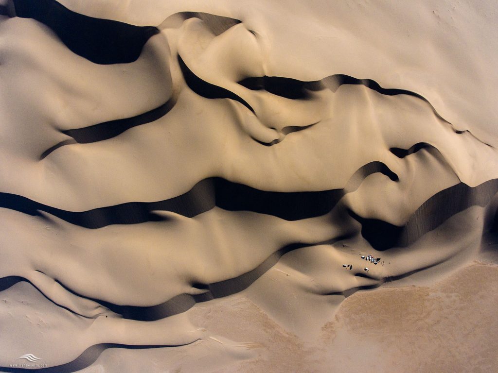
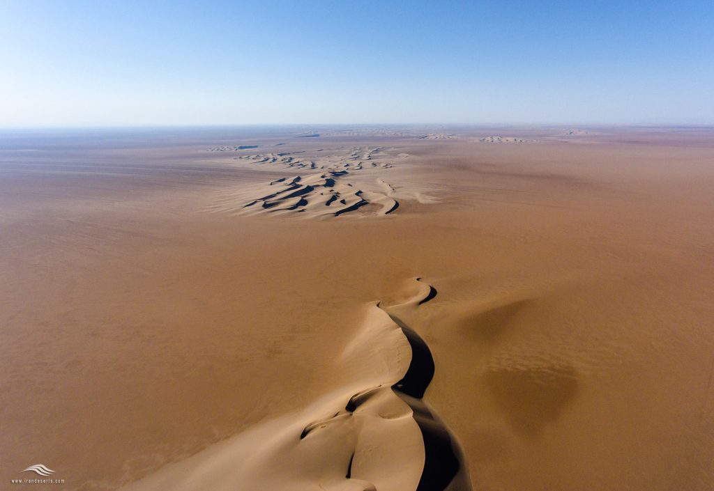
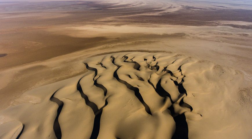
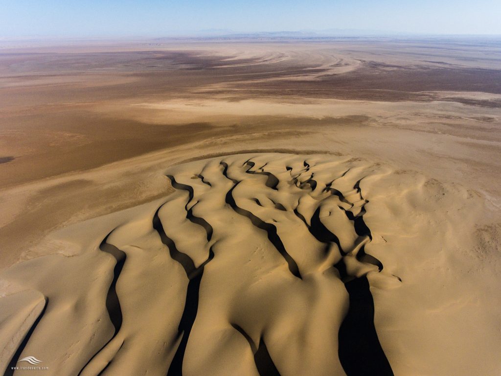
Great majority of this vast desert is covered with salty marches. The base of the area is a plain gas been eroded through the time featured with Moving sand dunes and no vegetation particularly in central, southern part of the area. In some parts there exists dunes of about 40 to 70 km long. The slope walls sometimes rising to 120m in height.
Clay deserts are spread in eastern and central part of Rig-e Jen with no plantation. Here the visitors see a desert wonder “inflated lands’-a roughly thick layer of sodium- soleplate has covered this area -. Sodium- soleplate is an ingredients of detergents, glass and paper. High groundwater level sometimes makes the clay lands wet in parts, the prevalent material is CACL2-that s of use for damp absorption. Some clay deserts located between wetlands and sandy walls are salt lands. Most salt lands are covered with potassium nitrates often used as a fertilizer.
Shour River flows into Garmsar Plain from southeast, its catchment area is Garmsar Plain and the surrounding mounts. Passing through Siah Kouh Mount slopes and drainages of the plain to northwest it gets to Rig-e Jen. The soil in this area is predominantly salty due to salt stones and domes existence, high level of groundwater in plain as well as high rate of evaporation
The northern part of Rig-e Jen has vast salt marches that along southern marches its salt rate is increasing.
The combination of sedimentology and stratigraphy allows us to build up pictures of the Earth’s surface here that is like the central desert of Iran.
The formed alluvial and sediments carried by the rivers mostly flows from northwest to southeast. Eroded and crushed materials covered the desert. Arriving into the desert. Widening of the river bed slow down the river flow and as a consequence the sediments spread over the plain.
Average altitude of Rig-e Jen in southern, western and eastern areas ranges from 700m to 720m (except sandy hills) and the altitude will decrease to 680 m in north. In north the high level of ground water has made wet clay deserts as well as salty wetlands
The biggest river in north eastern side of Rig-e Jen is Hableh Rood-a seasonal river flows from Garmsar northeastern mountains-. Yen, Rameh(Chartelegh)are other seasonal rivers flow from Garmsar northeastern mountains and Lezoreh area mostly featured with a little salty water. Some other rivers in north east and south east flows from surrounding mounts with no considerable flow of water. There is no water fountain in Rig-e Jen.
Sulfur Mountains located in North West of Rig-e Jen extended for 80 km like a curve from northeast to southwest at the very end of east salty domes are formed.
Gachab Mountains extended in northeastern part of Rig-e Jen for 40 km curved from east to west.
Nakhjir Mountains located in western side of Rig-e Jen that is connected to Satan Mount and Dam Mount in southwestern of Rig-e Jen.
Molla Hadi Mountains known as Bozorgi Mount located in southern part of Rig-e Jen. Also Zourmand Mount is in southeastern side of Rig-e Jen.
All mounts are extended on the desert margin and there is no mount in central part.
Rig-e Jen climatic conditions is like Iran central plateau. It is surrounded by high mountains a wall preventing the wet weather to get into central parts. Due to high rate of evaporation that is more than annual precipitation the climate, Rig-e Jen is arid with dry and hot weather.
Climatic conditions is changing and the sun rays are so strong and summers are long and too hot. As there is no weather stations in Rig-e Jen the meteorological information must be collected from surrounding cities on the desert margin. The lowest temperature recorded in Garmsar has been 4 centigrade in winter and the highest has been ever recorded reached 43 centigrade -recorded in August of 2000-. Considering a 5 degree of centigrade tolerance the temperature can get to roughly 48 in northern part of c in August and in southern part this figure reach 50 degree of centigrade. The highest relative humidity rate-71% normally is recorded in December and the lowest relative humidity is recorded in June-22%- . The meteorological study shows that on average annually relative humidity rate drops to below 50 that implies arid and dry weather and in in rest of the year-four months- because of rain fall the average humidity rises and can overcome the hot weather.
Arid lands and hot and dry weather as well as soil composition slowdowns the plant growth. In northern swampsswaps of Rig-e Jen no vegetation exist. Just in sandy slopes in western part of this vast desert one-year Haloxylon shrubs can survive-locally called Tagh- after the first year the shrubs can’t stand arid land and hot weather. In the margin of Rig-e Jen the situation is totally different. Some plantations that resistant to dryness and salt has adopted themselves to this arid land. Some of them are the followings: Salsola, Ashnan –from chenpodiaceae Family, Haloxylon, Tamarix and Alhagi.
In northwest and western part of Rig-e Jen –in vicinity of Siaah Mount and Nakhjir Mount madder bushes with thick stems grow very often. It is of use for carpet Warf and weft dying as well as burning for heat and cook.
Rig-e Jen steppes vegetation in the margin includes loliume perrene, Avena fatua, Mentha asiatica, Lactuca serriola, Acantholimon that all are one-year old herb. Some other bushes that grows here are Zygophyllum, Atraphaxis, Acanthophyllum-that is of medical use-.
The flora of Dam Rig area that has sand covered lands are: Haloxylon, Calligonum-rarely you can find here- going west ward this vegetation will get thicker and some other shrubs and herbs like Smirnova turkestana Bge, Astragalus Squarrosus and so on.
A vast area of Rig-e Jen has no flora and fauna and the available information on its vegetation and wildlife is unreliable and scattered. But in the margin of Rig-e Jen particularly on the mount slopes it has been reported to have some animals like Gazelle and zebra. On Rig-e Jen margin because of mild climatic conditions vegetation and biological diversity of a typical desert exist among animals, fox, sand cat, caracal, rabbit, gerbil, Pika, different types of snakes, scorpion, Agamidae Gecko, falcon, Buzzard, golden eagle, jackal and so on. Based in historians some centuries ago, the area was the habitat for flocks of deer –supposedly eradicated because of unobtrusive hunting. Rig-e Jen also includes a number of protected areas that are hunting prohibited areas like Molla Hadi, Abbas Abad in Naieen, Ardestan, Choupanan and particularly Kavir Nation Park that is the main habitat for Asian Cheetah. It is a common belief that some above-mentioned fauna live in Rig-e Jen
There is no document of human civilization in central part of Rig-e Jen, no sign of a city or village, whatever has been registered belongs to the surrounding and marginal areas.
Jindaq is a town and rural district) in the Ḵor and Biābānak district, Water for the rural district is obtained from subterranean channels (qanāt), deep and semi-deep wells, natural wells, and springs, while farming, gardening, herding, and rug weaving are the common professions. Here are historical relics dating back to about 2,000 years ago. The city has been located on the path of the historical Silk Road and has been a place where caravans rested. Torud is village away from Jindaq that the path was so impassable that was considered fata desert between north and south of Iran. Going through that was just possible at specific time of the year and fully equipped. Anarak is also of fame as town that hosted caravans travelling through Iran central desert. The town enjoys a museum with historic theme, mining background and a G eopark.
Dune of the Jinn is known as the scariest place in Iran. 3800 square km of a pure desert with many salt swamps in it with a whirlwind that brings death to any living creature. For a long time, local people believed no one could survive the spells and jinni of this place. The myths say that in the depths of this desert region there is a good place where everyone goes there no longer wants to return, but another group speaks of a Bermuda triangle. One of the most fascinating mysteries of this amazing area is 30 km south of the center of Rig-e Jen and the point of the intersection of the fifth wall and the tail of the river. This mystery refers to black stones that are seen in this area and are slag melting of mineral metals. Slag is an artificial and lateral product, which is obtained from impurities in the metal in the process of separating the metal in the melting furnaces and has various uses. Research on these rocks revealed that these slags were abandoned after the extraction of copper smelter from the mountains of Mount Molla Hadi and other copper mines. From the scientific point of view, the Bermuda Triangle theory and the disappearance of people in this area are far from the mind, but with the explanation that there is no extraordinary power in the disappearance of people, but the marshmallow people who have come from the wrong direction, they are thrown on the swamps It is so difficult to identify the marshes properly, in the case of clogged sounds, experts say that these voices are caused by the wind blow to the natural structures that were created due to sand displacement and wind erosion, they hear. But Experience the feeling of exploring a desert which people historically believed that it could not be crossed tempted for the first time in history, Sven Anders Hedin, a Swedish topographer and explore, crossed the southern edge of the Rig-e Jen and after that in 1997 Iranian Desert explorer.
The area was believed to be a cursed region which housed demons and evil spirits; residents of nearby towns and villages still hold similar ideas about the place and narrate stories about its mystery. It is widely believed that whoever sets foot in Rig-e Jen will die or disappear. This stories have created an ambiance of horror and among travelers going through this impassable rough nature, the worst experience has been scary sounds they have heard.